

Creating a “Google Maps for airports” – Travor’s approach
- Like
- Digg
- Del
- Tumblr
- VKontakte
- Buffer
- Love This
- Odnoklassniki
- Meneame
- Blogger
- Amazon
- Yahoo Mail
- Gmail
- AOL
- Newsvine
- HackerNews
- Evernote
- MySpace
- Mail.ru
- Viadeo
- Line
- Comments
- Yummly
- SMS
- Viber
- Telegram
- Subscribe
- Skype
- Facebook Messenger
- Kakao
- LiveJournal
- Yammer
- Edgar
- Fintel
- Mix
- Instapaper
- Copy Link
Posted: 11 March 2025 | Aviation Solutions | No comments yet
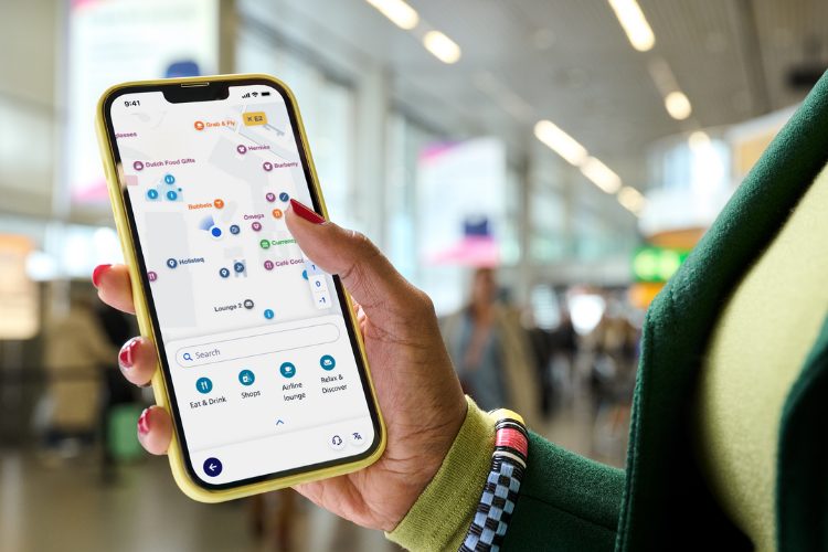
Imagine walking into a massive airport and knowing exactly where to go and how long it will take to get there—no stress, no confusion. With advanced indoor mapping, real-time data, and precise positioning, navigating terminals will feel effortless. Tijn Borms, Product Director of the Travor passenger experience platform at Aviation Solutions, shares his journey to bring Google Maps-style navigation to airports.
Indoor wayfinding is rare
Whether it’s finding a new restaurant, locating the nearest supermarket, or quickly spotting the closest gas station, we rely daily on the maps in our pockets, like Apple and Google Maps, to guide us wherever we need to go.
This technology is still rarely seen in indoor spaces like airports. Why?
The short answer is that airports are incredibly dynamic environments. Think of new routes, elevation changes, entrances that may be open one day and closed the next, and travellers with varying mobility needs. In practice, this makes creating a ‘Google Maps for airports’ very difficult.
Aviation Solutions, together with MappedIn, the global provider of dynamic indoor mapping solutions and services, has taken on the challenge of developing a working solution for Schiphol, the main international airport of the Netherlands. It’s one of the airports using the modular Travor passenger experience platform. “A solution is on the horizon, and it will be fully integrated within the Travor platform,” says Borms.
Time for coffee
Anyone who’s travelled knows the feeling: Your flight doesn’t leave for another hour, and you’d like to grab a coffee or a sandwich. But you’re not sure exactly what’s around or how far the walk is.
So, you decide to head to the gate anyway, only to find yourself waiting with nothing to do. According to Borms, this benefits no one: “The traveller gets bored and could have spent their time more enjoyably. And the airport misses out too, as they want travellers to have the best experience possible.”
By introducing wayfinding and blue dot technology, travellers can better decide how to spend their time. It makes it easier to order that extra coffee or try on that shirt they saw hanging in the shop. This is commercially interesting for airports, and it also improves the travel experience. And according to Borms, there are even more reasons to tackle this challenge.

In an ideal situation, travellers arrive precisely on time and immediately find the correct route. But that’s not the reality. People often arrive too early or too late, and each traveller has different needs. This makes airport operations less predictable. But if you help passengers know exactly where they are and what’s nearby, you can help them enjoy the airport amenities and arrive on time, for example by sending subtle notifications to their phone.
Travelling can be a stressful experience for many, Borms adds: “That’s why you want to give travellers as much transparency and insight over the entire process as possible. The airport automatically benefits from this too.”
Faraday cage
So, there are plenty of reasons to have an interactive map at the airport. Currently, however, Schiphol has an offline map without wayfinding, which often becomes outdated very quickly due to constant changes in the terminal. Manually updating these maps is also a time-consuming and costly process.
This needs to change – but why is it so difficult to create an online map with wayfinding?
“An airport map has to take into account the complex and dynamic infrastructure of a terminal. Unlike standard maps like Google Maps, an airport requires very specific route configurations,” says Borms.
For example, travellers cannot simply use every door or area due to restrictions, different floors, airside/landside areas, and specific routes for staff. Additionally, routes regularly change due to temporary closures for maintenance, broken elevators, or security measures. This requires a system that can adapt in real-time.

Traveller needs also vary. Some have luggage, others don’t, and a different route is needed for people in wheelchairs compared to travellers without mobility limitations.
Another challenge is “blue dot” technology, or real-time location tracking within the terminal. “Airport terminals are often made of steel structures that act like a ‘Faraday cage’. This limits indoor positioning and makes it inaccurate. To pinpoint which floor the user is on, the system also needs additional signals.
Wayfinding and blue dot
According to Borms, the solution is “difficult, but not impossible.” Together with MappedIn, Aviation Solutions is determined to radically improve how we navigate airports. Schiphol currently serves as a proving ground for this technology.
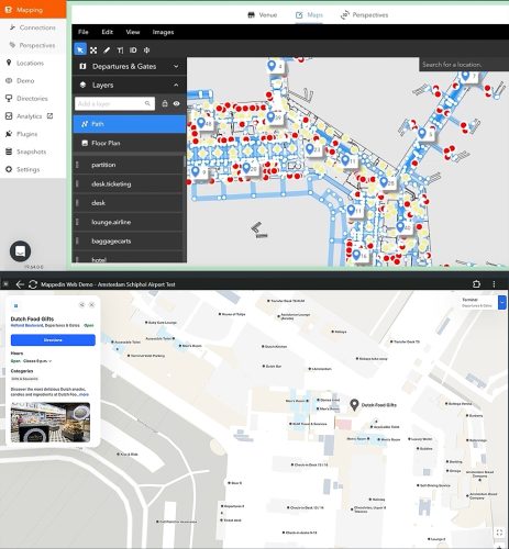
“The team at Aviation Solutions challenged us to build a product that goes beyond a solution that includes location, real-time security, flights, and parking,” said Yuval Kossovsky, Managing Director for Transportation at MappedIn. “A first of its kind for the industry, our GeoDataSync synchronises and validates geometry on a daily basis—a game-changing solution built for the complexities of airports.”
In the short term, automatic updates of digital maps will be implemented. Every 24 hours, the terminal layout will be refreshed using data from the Mappedin Content Management System. This ensures that changes to routes or closed passages are immediately visible and eliminates the need for manual updates and provides travellers with the most accurate and up-to-date information.
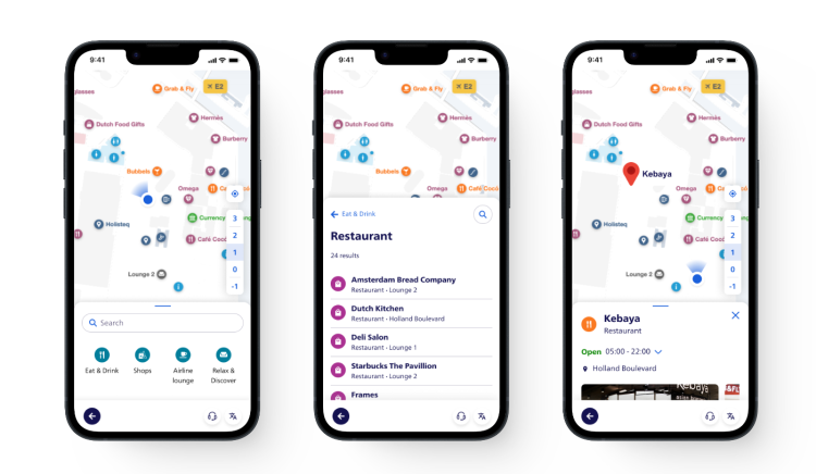
A smart route planner, similar to Google Maps, is also being introduced. This planner takes into account specific requirements such as Schengen and non-Schengen zones, different floors, airside and landside areas, and staff routes. By integrating these elements, the system can offer routes tailored to the unique constraints of an airport environment, while ensuring navigation remains intuitive for travellers.
Access and accuracy
Aviation Solutions prioritises broader accessibility over pinpoint precision. That’s why they focus on browser-based technology rather than app-based solutions that travellers have to download. As Borms explains: “We’d rather improve accuracy from 30 meters to 10 meters for 80% of users than aim for sub-meter accuracy for only 5%.”
App-based solutions benefit from direct access to hardware features like gyroscopes, accelerometers, magnetometers and BLE beacons, but these resources are currently not available in a web environment.
Therefore, there are currently only three viable solutions: Apple’s approach (exclusively for iPhones), Google’s approach (exclusively for Android devices), and technologies that rely on a phone’s camera. Each option has its own advantages and limitations.
Apple versus Android
To maximise Apple’s solution, a map in ‘IMDF-format’ must be provided, and the terminal must undergo “fingerprinting.” This process involves mapping WiFi signal strengths at specific locations within the terminal. It teaches your phone how these signals behave. Using signal fusion, Apple combines this data with other inputs to determine a travellers’ location. While occasional re-fingerprinting is necessary to maintain optimal performance due to changes like new walls or crowd density, the system can reliably guide travellers in many scenarios.
Google’s round-trip-time (RTT) technology offers an even more accurate alternative by measuring the time WiFi signals take to travel to and from access points. Unlike signal strength-based methods, RTT is less impacted by obstacles such as walls or crowds and does not require frequent re-fingerprinting.
However, this technology depends on the availability of access points supporting the 802.11mc protocol, which is still relatively new and not yet widely deployed. “Coincidentally, Schiphol had just installed new WiFi access points with this protocol, so that came in handy,” says Borms.
Pinpoint accuracy
There are scenarios where Apple’s and Google’s technology may not provide enough precision. Think of the Schengen/non-Schengen border for example, where pinpoint accuracy is crucial.
Aviation Solutions is therefore also experimenting with camera-based point cloud technology. Passengers briefly scan their surroundings using their phone’s camera, and the system matches this data against a 3D point cloud of the terminal to determine their exact location and orientation.
“The hardest thing about airport wayfinding is balancing available technologies, ease of use, and respect for the traveller’s phone battery,” said Jere Suikkila, VP of Enterprise Integrations at MappedIn. “We streamline positioning for a passenger’s exact location and the exact direction they’re facing and then use WiFi location to pick up a reasonably accurate blue dot that uses very little battery.” He added, “This will suffice for 95% of travellers, and for the other 5%, we provide a specialised solution.”
Unlike augmented reality applications that rely on continuous scanning, this method provides a one-time, highly accurate location. The solution is designed to integrate seamlessly with Travor. This will allow airports that use Mappedin to use this functionality without writing a single line of code.
A glimpse into the future
The rollout of the updated mapping system is scheduled for 2025. First, digital maps will be available in the app and traditional printed maps will be replaced by screens. The interactive Travor route planner will be added later.
And what does the distant future hold? According to Borms, Augmented Reality might play a role in navigation. “Imagine everyone walking around with the sixth generation of Apple Vision Pro, now as compact as regular glasses or maybe even integrated in a contact lens.” This could redefine the look of airports, Borms says, adding “Perhaps all physical signs could even disappear—but for now, our focus remains on making that blue dot in Travor a reality for all airports using our platform.”
Related topics
Accessibility, Passenger experience and seamless travel, Terminal operations


 Chief Executive Officer
 CEO
CEO Chief Operating Officer
 Head of Operations, Safety and Emergency
 Chief Strategy Development Officer
 Head of Operations
 Airport General Manager
 CEO
CEO Chief Executive Officer